Transit Center District Plan
Project Status: Completed
The Transit Center District Plan – a Sub Area Plan of the Downtown Plan, was adopted in May 2012 into the General Plan.
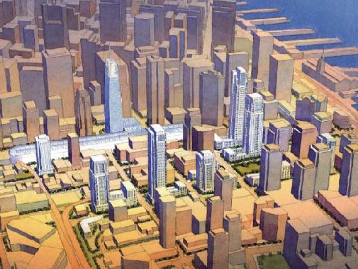
This Plan builds on the City’s renowned 1985 Downtown Plan that envisioned the area around the Transbay Terminal as the heart of the new downtown.
The Planning Department received funding from the San Francisco County Transportation Authority to draft a comprehensive plan for the area around the Transbay Terminal, including mechanisms to direct any increased development value to help fund the construction of the Transit Center Program in addition to other public improvements. Consistent with the Transbay Redevelopment Plan, which focuses mostly on public properties south of the Transit Center along Folsom Street, this effort focused on both private properties and properties owned or to be owned by the Transbay Joint Powers Authority around the Transit Center itself.
The City adopted the Urban Design Element of the General Plan in 1971 and the Downtown Plan in 1985, laying the groundwork for the downtown San Francisco we know today: a compact, walkable and dynamic urban center and a dramatic skyline set against the natural backdrop of the city’s hills. The Downtown Plan established the growth of the downtown south of Market Street, with its core of greatest density and greatest heights around the Transbay Terminal. At the time, the Embarcadero Freeway created a sharp southern edge to the downtown south of Howard Street. Since the elevated freeway’s removal, the City has undertaken several major planning efforts for new downtown neighborhoods (including Rincon Hill and Transbay) and infrastructure investments (Transbay Transit Center). These changes, as well as the fact that significant growth has happened in the 20 years since the Downtown Plan was adopted, demand a new look at the land uses, urban form and public realm of the downtown core. This planning effort is intended to shape the next generation of downtown growth; it will build on the core cherished principles of city building at the heart of the Urban Design Element and Downtown Plan.
In early 2006, a Mayor’s Interagency Working Group reviewed development assumptions in the existing Transit Center Program to determine the appropriate planning response to this facility in the heart of downtown San Francisco and to assess ways of securing additional funding for the Program. This brief assessment concludes that raising certain height limits and increasing development potential in the area would be consistent with the City’s vision for the Transit Center district. It identifies a potential for generating additional funds for the Program through increased tax increment, land sales, and assessments, which would result from such changes in controls of land use and urban form. The Working Group also identified the possibility for air-rights development at the 4th/King rail station and yards to provide additional funding for the Program.
Objectives
- Build on the Urban Design Element and Downtown Plan, analyze modifications to the downtown form based on new Transbay and Rincon Hill plans and recent development.
- Capitalize on major transit investment with appropriate land use response in the downtown core.
- Set guidelines and standards to build a high-quality public realm and provide public amenities.
- Generate more revenue for the Transbay Transit Center project and other public improvements.
Project Schedule and Public Process
|
JULY 25 , 2007
|
Public Workshop #1 (Introduction to the planning effort and key objectives) |
|
APRIL 30, 2008
|
Public Workshop #2 (Land Use/Growth, Draft Urban Form, Historic Preservation, Public Realm Concepts) |
|
SEPTEMBER 17, 2008
|
Public Workshop #3 (Quality of Place: Urban Design, Open Space, Zoning, Historic Resources, and Sustainability) |
|
MAY 26, 2009
|
Public Workshop #4 (Public Benefits/Financial Plan and Final Proposals) |
|
NOVEMBER 19, 2009
|
Publication of Draft Plan for public review |
|
SEPTEMBER 28, 2011
|
Publication of Draft Environmental Impact Report |
|
NOVEMBER 28, 2011
|
Comment Period Closes on Draft EIR |
|
APRIL 19, 2012
|
Informational Hearing at Planning Commission We will refresh the Commission about the Plan’s proposals and discuss revisions, updates and refinements to the draft Plan proposals. On this day the packet of key plan adoption materials will be delivered to the Commission and made available to the public, including draft Planning Code, Zoning Map and General Plan amendments. The full packet of materials will be posted here on our project website by close of business on Friday April 20. |
|
MAY 2, 2012
|
Article 11 Initiation Hearing at Historic Preservation Commission |
|
MAY 3, 2012
|
Plan Initiation Hearing at Planning Commission At this hearing we will continue the informational discussion and ask that the Commission formally initiate the amendments so that an adoption hearing can be held three weeks later. |
|
MAY 24, 2012
|
Final EIR Certification and Plan Adoption at Planning Commission |
Final adopted Area Plan and Planning Code amendments
- Draft Transit Center District Plan
- Draft Plan Addendum
- General Plan Amendments including Case Report, Draft Resolution, Draft Ordinance, and Draft Sub-Area Plan
- Planning Code Amendments including Case Report, Draft Resolution, Draft Planning Code Amendments
- Zoning Map Amendments including Case Report, Draft Resolution, and Draft Ordinance
- Implementation Package, including Draft Administrative Code Amendments and Draft Program Implementation Document
Planning Commission Initiation Packet
Environmental Impact Report (2007.0558E and 2008.0789E)
Historic Preservation
Historic Resources Survey & Context Statement (Adopted July 2008 and February 2012)
- Context Statement
- Individual Survey (DPR) Forms
- New Montgomery-Mission-2nd Street District (DPR) Form
Transit Center District Plan Historic Preservation Policies and Objectives
Presentations & Project Materials
- Public Meeting presentation on Financial Program/Public Benefits. May 26, 2009
- Public Meeting presentation on Quality of Place, Sept. 17, 2008
- Public Meeting presentation on Initial Findings & Proposals, April 30, 2008
- Urban Form Simulations
- Downtown 2035 Growth/Capacity Analysis
- Introductory Public Workshop Presentation, July 25, 2007
- Informational Presentation to the Planning Commission, February 1, 2007
Consultant RFPs & Scope
- EIR Consultant RFP
RFP - Transit Center District Plan and Transit Tower EIR (Amended 8-24-07)
RFP - Appendix A Part 1
RFP - Appendix A Part 2
RFP - Appendix C
RFP - Appendix D
Questions & Answers - Transit Center District Plan and Transit Tower EIR - RFP Pre-Bid Presentation August 7, 2007
- EIR Consultant RFP Bidder's Conference Sign-In Sheet
- Planning Consultant RFP
- Scope of Work for Downtown Growth Forcasting and Analysis - Seifel Consulting
- Informal RFP for Shadow Methodology and Preliminary Assessment
Background
Mayor’s Interagency Transbay Working Group
Transbay Joint Powers Authority—Transit Center Program
San Francisco Redevelopment Agency—Transbay Redevelopment Project
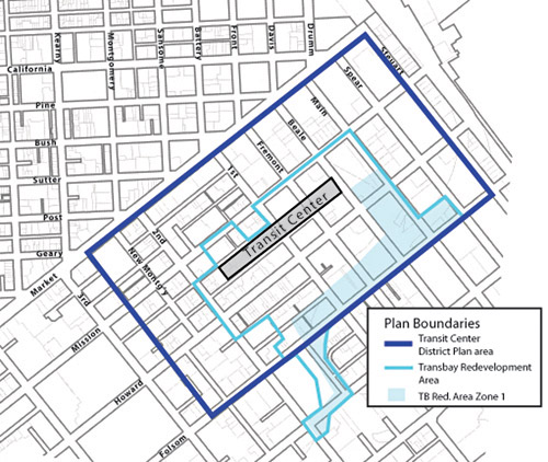
The boundaries of the study area for the Transit Center District Plan are roughtly Market Street on the north, Steuart Street on the east, Folsom Street on the south, and mid-block between 3rd and New Montgomery Streets on the west. The Plan will not affect the adopted land use or development controls for Zone 1 of the Transbay Redevelopment Area.
The Transit Center District Plan will build on the City’s renowned 1985 Downtown Plan that envisioned the area around the Transbay Terminal as the heart of the new downtown. This new effort will analyze land use and urban form responses to the maturation of the southern side of downtown since 1985 and the infrastructure investments now planned. Following detailed analysis and computer simulation (e.g. urban form, shadow, wind, circulation), the study will produce new planning policies and controls for land use, urban form, building design, and public realm improvements for private properties as well as for properties owned or to be owned by the Transbay Joint Powers Authority in and around the adopted Transbay Redevelopment Project Area and Transbay Terminal. The study will also propose a mechanism for directing some financial benefit from any increases in development opportunity to the construction of the Transit Center Program and other public amenities and infrastructure in the area.
Notice to Project Sponsors in the Transit Center District Plan Area and Vicinity - PDF