Maps
Last Updated: 04/19/2024
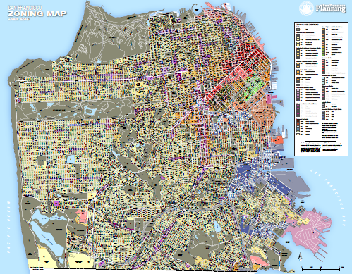
Zoning Use Districts
Purchase of Map Suspended: The department is suspending printout service for this item. If you require hard copy printouts, please consider other services, such as FedEx/Kinko's or OfficeMax.
Individual zoning districts on the map are labeled, along with block numbers. A concerted effort was made to maintain traditional coloring schemes for these zoning districts:
- Residential is yellow
- Neighborhood Commercial is purple
- Downtown is red
- Industrial is blue/gray
- Mixed use in its multiple variants is light orange
Note: due to the number of zoning districts used on this map, one district is difficult to differentiate from an adjacent district by color alone, hence the labeling of districts. Please route any errors or omissions to diana.la@sfgov.org.
Other Zoning Resources
- Find specific zoning information for an address using the SF Property Information Map and selecting the Zoning Information tab
- The zoning data displayed on this map can be downloaded from data.sfgov.org
- Zoning Maps via Planning Code