Sea Level Rise Adaptation
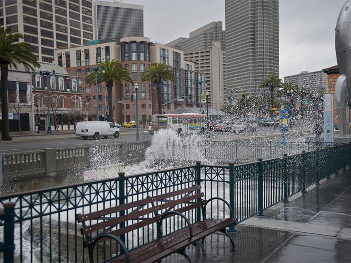
Sea level rise is a slow-moving threat, but it demands immediate action. Global heating creates extreme hazards that cause significant harm to people, homes, infrastructure, and the environment. In California, we are already facing many climate-related impacts: prolonged drought, extreme heat, massive wildfires, hazardous air quality, flooding, and severe weather. San Francisco Planning is working in collaboration with other City departments and community stakeholders to identify the impacts of coastal flooding due to climate change, and to determine strategies to make San Francisco more resilient in the face of rising sea levels.
Sea Level Rise Vulnerability and Consequences Assessment (2020)
- Executive Summary
- Full Report (large file - 243MB)
- Report by Chapters
- Cover and Executive Summary
- 01 - Introduction
- 02 - SLR Climate Science and Scenarios
- 03 - Assessment Approach
- 04 - Supporting Assessments
- 05 - Transportation
- 06 - Water
- 07 - Wastewater
- 08 - Power
- 09 - Public Safety
- 10 - Open Space
- 11 - Port
- 12 - Neighborhood Consequences
- 13 - A Changing Shoreline
- 14 - Next Steps
- Fact Sheet
- Presentation to Planning Commission (May 23, 2019)
Sea Level Rise Action Plan (2016)
- Executive Summary
- Full Report
- Presentation to Planning Commission (March 10, 2016)
Hearings and Meetings
The City has made a series of public presentations at City Boards and Commissions over late 2019 and early 2020.
- Planning Commission, May 23, 2019
- Capital Planning Committee, July 22, 2019
- Port Commission, October 22, 2019
- Presentation to San Francisco Municipal Transportation Agency (SFMTA) Board Policy and Governance Committee (November 26, 2019)
- SF Public Utilities Commission, December 10, 2019
- Environment Commission, January 28, 2020 – forthcoming
- Recreation and Parks Commission, February 20, 2020 – forthcoming
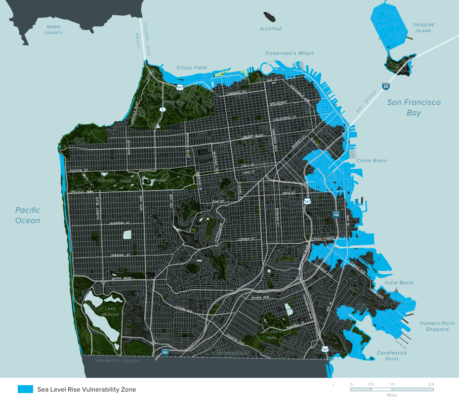
By the end of this century, global heating will cause sea levels around San Francisco Bay may rise three to six feet or more1. Coupled with more extreme weather patterns, over six percent of San Francisco’s land (about four square miles), called the Sea Level Rise Vulnerability Zone, could be inundated by temporary or permanent flooding. This area is home to more than 37,000 people, 170,000 jobs, and a host of vital infrastructure, including roadways, utilities, emergency services, roads, bridges, transit, parks and open spaces, and the Port of San Francisco.
The Sea Level Rise Vulnerability and Consequences Assessment moves the City forward toward reaching the goals set out in the Sea Level Rise Action Plan (2016). Recognizing the urgent need to adapt our waterfront communities to sea level rise (SLR) and coastal flooding, the City prepared the Sea Level Rise Vulnerability and Consequences Assessment. The Assessment describes the vulnerability of public buildings and infrastructure to SLR and coastal flooding and the consequences on people, the economy, and the environment. It includes a series of illustrative neighborhood profiles that describe how neighborhoods would be impacted by sea level rise and coastal flooding over time, with a focus on vulnerable communities. The Neighborhood Profiles consider how different infrastructure categories impact each other and affect the daily lives and well-being of people living and working in these neighborhoods.
The Assessment studied 10 SLR scenarios ranging from 12 to 108 inches to understand the City’s infrastructure vulnerabilities to intermittent and permanent flooding over time if no actions are taken to address SLR.
It identifies City-owned infrastructure within the SLR Vulnerability Zone by sector, including: Transportation, Water, Wastewater, Power, Public Safety, Open Space, and Port Facilities.
The information in the Assessment will be used to advise decision makers, City agencies, and public stakeholders as they develop, prioritize, design, and build appropriate adaptation strategies to enhance San Francisco's resilience to SLR and coastal flooding.
We will continue to work with communities to develop plans, policies, and projects to adapt the City to SLR, coastal flooding, and other hazards.
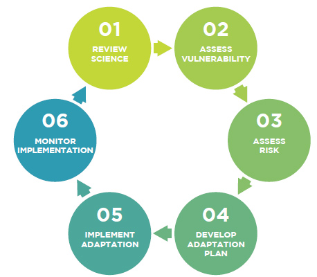
The Assessment completes Steps 2 and 3 in the SLR Action Plan process: Assess Vulnerability and Assess Risk.
Download the Sea Level Rise Vulnerability and Consequences Assessment.
1. The Sea Level Rise Vulnerability and Consequences Assessment uses the State of California Sea-Level Rise Guidance (updated in March 2013) based on the best available science, analysis and mapping at the time. It should be noted that in 2018, the State of California Sea-Level Rise Guidance was updated to reflect advances in sea-level rise science and address the needs of state agencies and local governments as they incorporate sea-level rise into their planning, permitting, and investment decisions.
Approximately four-square miles of San Francisco (not including Treasure Island or San Francisco International Airport) are located within the City’s SLR Vulnerability Zone. The SLR Vulnerability Zone is 108 inches above today’s high tide (mean higher high water, or MHHW). This includes 66 inches of SLR plus 42 inches of tidal and storm surge, an upper-range scenario for end of century. The Sea Level Rise Vulnerability and Consequences Assessment uses the State of California Sea-Level Rise Guidance (updated in March 2013) based on the best available science, analysis, and mapping at the time. It should be noted that in 2018, the State of California Sea-Level Rise Guidance was updated to reflect advances in sea-level rise science and address the needs of state agencies and local governments as they incorporate sea-level rise into their planning, permitting, and investment decisions.
Within the SLR Vulnerability Zone, the Assessment studied 10 scenarios within ranging from 12 to 108 inches to understand the progression of the City’s infrastructure vulnerabilities to intermittent and permanent flooding. The SLR Vulnerability Zone is also used to identify capital projects that use the City’s SLR Capital Planning Guidance.

Released in March 2016, the Sea Level Rise Action Plan defines an overarching vision and set of objectives for future sea level rise and coastal flooding planning and mitigation in San Francisco.
Proactive, thoughtful adaptation planning will allow San Francisco to minimize risks and meet the challenges posed by rising seas. The innovation, creativity, and inclusivity that have always inspired growth and development in San Francisco will support both sea level rise adaptation and continued growth as a leading global city.

The Action Plan describes a series of steps to make San Francisco more resilient in the face of rising sea levels. The Action Plan defines goals and guiding principles for sea level rise planning and creates a roadmap to develop vulnerability and risk assessments and adaptation strategies.
Mayor Lee assembled the Sea Level Rise Coordinating Committee in March 2015, an interagency task force of twelve City departments co-chaired by San Francisco Planning and the Office of Resilience and Capital Planning to develop a comprehensive understanding of the threat of sea level rise and to create a decisive plan of action. The Sea Level Rise Action Plan is the Committee’s first task.
The Sea Level Rise Action Plan completes four strategic tasks:
- Establishes an overarching vision, goals, and a set of guiding principles for sea level rise planning;
- Summarizes current climate science, relevant policies and regulations, and vulnerability and risk assessments conducted to date;
- Identifies data gaps and establish a framework for further assessment, adaptation planning, and implementation; and
- Provides the foundation and guidance to develop a citywide Sea Level Rise Adaptation Plan
Download San Francisco’s Sea Level Rise Action Plan.
Danielle Ngo
Senior Planner, Resilience + Sustainability
danielle.ngo@sfgov.org
628.652.7591
