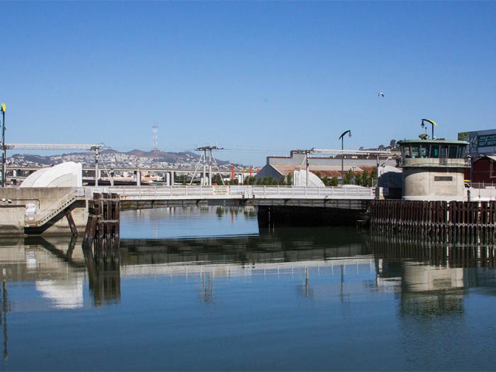
Islais Creek Adaptation Strategy
Project Status: Completed
The Islais Creek Adaptation Strategy is a long-range vision for the Islais Creek shoreline to protect transportation infrastructure, enhance shoreline access and habitat, and nurture community resiliency in adjoining neighborhoods. It also identified implementable near- and mid-term investments that build towards that long-term vision.
Download the final Islais Creek Southeast Mobility and Adaptation Strategy, published in August 2021.
A two-year community planning process in the Islais Creek area, with actionable strategies that address sea level rise and coastal flood risk through a robust public engagement process. Building on the Resilient by Design proposal and other city and regional efforts, the Islais Creek Adaptation Strategy's long-range vision for the Islais Creek shoreline centers on asset-specific solutions for public infrastructure, and a prioritized funding and implementation strategy to increase the resilience of the community and provide improved transportation networks and new open space.
Background
A changing climate will have profound impacts on San Francisco’s communities and its shoreline. To minimize climate impacts, we need to simultaneously reduce greenhouse gas emissions while preparing for future climate impacts such as sea level rise and coastal flooding.
Sea levels are anticipated to rise 6-10 feet by 2100 and over the next several decades, coastal flood events are projected to increase in frequency and extent. Addressing this climate risk requires urgent action now and will ultimately help to build a more resilient city.
Sea level rise poses a threat to San Francisco’s neighborhoods and communities, critical shoreline infrastructure and the transportation system. One approach to building community resiliency is to begin the process of identifying vulnerabilities and developing robust strategies that address climate-related risks and vulnerabilities.
These changes will continue to increase flood risk and impact. The Port, San Francisco Planning, and SFMTA are partnering with agencies at the federal and state levels to study risks and needed improvements. Proactive planning will help ensure the safety of citizens and prevent serious damage to vulnerable waterfront communities and city infrastructure over the long term.
Other Resilience Efforts Underway at Islais Creek
The Waterfront Resilience Program encompasses multiple interrelated efforts to understand the severity and progression of climate change impacts, involve the people and communities that could be potentially affected by flooding or earthquakes, and create ideas and actions to protect communities, the economy, and the environment. These efforts include the U.S. Army Corps of Engineers/Port Flood Study, the Islais Creek Adaptation Study, and the Southern Waterfront Seismic Vulnerability Assessment.
The Islais Creek Adaptation Strategy is one of three projects addressing climate hazards (flooding, seismic risk) in the area. Below are details on the two other projects (see the Timeline tab for more information about phasing).
Army Corps Flood Study
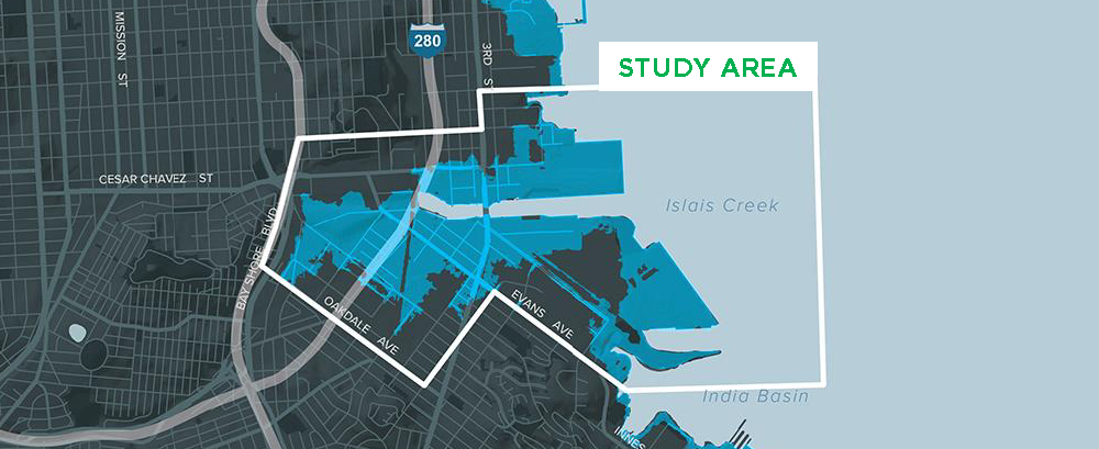
The United States Army Corps of Engineers and Port of San Francisco have partnered to study flood risk along San Francisco’s eastern shoreline. The study area is within the Port’s jurisdiction, from Fisherman’s Wharf in the north to Heron’s Head Park in the south.
The three year Study will identify challenges and recommend solutions to reduce current and future flood risk and will produce alternatives that will incorporate input from USACE, Port, stakeholder, resource agencies and the public for consideration for Federal investment and implementation.
The Port is excited to share what’s been learned through the Study, considerations for adaptation, and community feedback through 15 Story Maps, an interactive map-based tool that allows you to see how earthquake and flood may impact community spaces, disaster response sites and services to keep us safe in an emergency, utilities that keep the city running, and more. The story focused on Islais Creek is linked here.
Southern Waterfront Assessment
The Port is leading an effort in the southern part of the Port’s jurisdiction to assess the vulnerabilities, identify the opportunities and develop near, mid- and long-term adaptation strategies for the area. The purpose of the assessment is to fill any gaps in the Port, City and community understanding of the risks and opportunities. The Assessment will draw from, and integrate with, a number of existing efforts, including Islais Creek Adaptation Strategy, the Seawall Program, the USACE/ Port of San Francisco Flood Protection Study, the Citywide Sea Level Rise work.
The two-year planning project began in early 2019 and, due to COVID-19, was extended and concluded in June 2021.
Resources
- Islais Creek Southeast Mobility Adaptation Strategy Final Report (August 2021)
- Implementation and Financing Strategies (August 2021)
- Economic Impacts of the Near-term Strategies on Port Assets (August 2021)
- Presentation to Planning Commission (June 3, 2021)
- Guiding Principals and Goals for the Islais Creek Adaption Strategy (April 2020)
- Islais Creek Adaptation Strategy Overview Handout
- Waterfront Resilience Program (Port of SF microsite)
Press and Media
- Press Release: New Resilience Strategy Helps Protect One of City’s Most Dynamic Waterfront Ecosystems (August 6, 2021)
- Is It Finally Time to Daylight Islais Creek? (The Frisc, December 19, 2019)
- Race against time (SF Chronicle, September 17, 2019)
- San Francisco’s Islais Creek Adaptation Strategy Kicks off to Protect Public and Private Assets (The Registry, April 25, 2019)
Schedule and Event Materials
| Meeting | Details | Event Materials (will be posted after completed event) |
|---|---|---|
| Community Meeting #1: Thursday, March 14, 2019 Bayview Opera House 4705 Third Street San Francisco, Ca 94124 | Project Introduction Mapping Assets | |
| Community Meeting #1.5: Thursday, September 19, 2019 Southeast Community Facility 1800 Oakdale Avenue San Francisco, Ca 94124 | Mapping Assets and Prioritizing Co-Benefits | |
| Holiday Mixer Thursday, November 21, 2019 Radio Africa Kitchen 4800 3rd Street, San Francisco CA 94124 | Mapping Assets and Prioritizing Co-Benefits | |
| Islais Creek / Bayview Resilience Walking Tour #1 Saturday, January 11, 2020 10:00 AM – 11:30 AM Meet at 1698 Indiana Street | Explore the Creek and Witness the King Tides | |
| Community Meeting #2 Thursday, January 30, 2020 6:00 – 7:30 PM Southeast Community Facility, 1800 Oakdale Ave, San Francisco, CA 94124 | Public Feedback on Adaptation Vision, Goals, Priorities and Trade-offs | |
| Islais Creek / Bayview Resilience Walking Tour #2 Postponed due to COVID-19. | Explore the Creek and Witness the King Tides | |
| Community Meetings Postponed due to COVID-19 until further notice. Date and Time to be Announced (Expected Early 2021) | Public Feedback on District-Scale Concept Design, Design Alternatives, and Asset Strategies |
|
| Youth Engagement Spring 2020, Fall 2020 | Work with 2nd and 4th graders at Monroe Elementary, 4th graders at Malcolm X Academy |
|
| Community Circle-Backs: Wednesday, May 19, 2021, and Tuesday, May 18, 2021 | Public Feedback on flood-resilience ideas for the Islais Creek area |
Partner Agencies
Supporting Agencies
- U.S. Army Corps of Engineers
- Bay Area Rapid Transit
- SF County Transportation Authority
- SF Public Utilities Commission
- SF Public Works
- Office of Resilience and Capital Planning
Project Funding
Caltrans Transportation Planning Grant Program with funding from Senate Bill 1.