Yosemite Slough Neighborhood Adaptation Strategy
Project Status: Completed
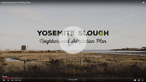 Watch this brief video to learn more about the history of Yosemite Slough and the vision for a more climate resilient Bayview.
San Francisco faces significant flood risks with sea levels projected to rise from 3 to nearly 7 feet by 2100. The Yosemite Slough Neighborhood Adaptation Strategy (“the Strategy”) recommends measures to protect the Bayview neighborhood surrounding Yosemite Slough from the impacts of sea level rise and coastal flooding. The Strategy advances environmental justice in Bayview Hunters Point by building community capacity and positioning the neighborhood for funding to develop a Neighborhood Adaptation Plan. The Strategy, released February 2026, is now available.
Project Area
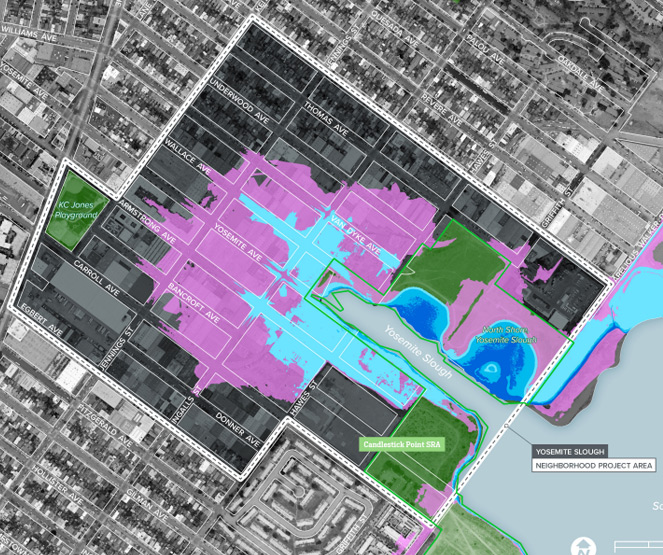
Click on image to view detailed map.
The project focuses on the areas at risk from sea level rise flooding around Yosemite Slough, shown within the white dotted line on the map.
The project area is bound by Arelious Walker Drive to the southeast, Shafter Avenue to the northeast, Keith Street and 3rd Street to the northwest, and Egbert Avenue and Carroll Avenue to the southwest.
FAQs
Yosemite Slough Neighborhood Adaptation Strategy
What is the Yosemite Slough Neighborhood Adaptation Strategy?
The Yosemite Slough Neighborhood Adaptation Strategy (YSNAS) recommends measures to protect Bayview Hunters Point from sea level rise and flooding. The project area focuses on the residents, businesses, and infrastructure around Yosemite Slough, located between Hunters Point and Candlestick Point (see map). The Strategy is a critical first step to securing state and federal funding for climate adaptation in Bayview Hunters Point.
What is the project timeline?
- Outreach and Technical Analysis: Winter 2024 through Fall 2025
- Strategy Development: Summer 2024 through Fall 2025
- Strategy Completion: February 2026
Why is this work needed? Why is it important?
Today, Bayview Hunters Point is already vulnerable to stormwater and coastal flooding. If no action is taken, the neighborhood is at risk of significant flooding from sea level rise in the near future. The latest scientific data shows projections of tides that are nearly one foot higher than current levels by 2050. This is a slow-moving disaster and may worsen over time. YSNAS identifies preventive actions to protect the neighborhood before rising tides severely threaten the neighborhood.
Bayview Hunters Point & Yosemite Slough Wetland
What is Yosemite Slough?
Yosemite Slough (rhymes with “blue”) is a wetland located between Hunters Point and Candlestick Point. Historically, it was part of a larger watershed, originating from what is now McLaren Park. Yosemite Slough was once a biologically-rich ecosystem that supported a variety of wildlife, including many migrating birds.
How does this relate to Candlestick Point State Recreation Area?
The immediate shoreline, and areas to the north and south of Yosemite Slough, are part of the Candlestick Point State Recreation Area. Candlestick Point is owned and managed by the California Department of Parks and Recreation (“State Parks”). The adjacent residential and commercial parcels are privately owned, but under the jurisdiction of the City and County of San Francisco (“the City”). This YSNAS project is sponsored by the City, and will be coordinated with State Parks and other stakeholders.
What work has been done at Yosemite Slough?
State Parks and the California State Parks Foundation restored wetlands and built core infrastructure along the north shore of Yosemite Slough, including trails, perimeter boundary markers, and a parking lot. Literacy for Environmental Justice, a Bayview Hunters Point-based organization, helped plant thousands of native trees, shrubs, and perennials. In 2024, State Parks completed a shoreline stabilization study to inform future projects along the Candlestick Point waterfront.
How is this work related to Hunters Point?
Yosemite Slough is adjacent to the Hunters Point Naval Shipyard. The U.S. Navy is responsible for environmental remediation of the Shipyard, which is considered a Superfund site. Yosemite Slough is a separate Superfund site with a different contamination profile than the Shipyard.
What is being done about contamination?
The north shore of Yosemite Slough was cleaned up as part of the wetland restoration project, led by State Parks and the California State Parks Foundation. The U.S. Environmental Protection Agency (EPA) is working with various responsible parties to design a cleanup strategy for the slough itself. The cleanup is expected to remove contaminated mud and replace it with clean materials. To maintain the restored wetland habitat and avoid recontamination, the cleanup must align with the cleanup of the Shipyard. As of Fall 2024, the EPA estimates the cleanup of Yosemite Slough to begin in 2028.
Sea Level Rise and Flooding
What is sea level rise?
As the Earth warms, glaciers and polar ice sheets melt, and ocean water expands in volume. Both factors are causing sea levels to rise. The warmer the planet, the faster the sea levels will rise. With more sea level rise, the San Francisco Bay rises. When accounting for high tides and more extreme storms, the Bay is expected to rise between 3 and 6.6 feet by 2100.
How does sea level rise interact with stormwater flooding (flooding from rain) and groundwater flooding (flooding from water emerging above the land’s surface)?
When it rains, stormwater is captured by the City’s combined sewer system, gets filtered alongside wastewater, and then let into the San Francisco Bay. When there are extreme storms, there can be more stormwater than the system can handle. This can lead to stormwater flooding in low-lying areas and combined sewer discharges. The intensity, duration, and frequency of extreme storms is expected to increase with climate change, making the City more vulnerable to this kind of flooding.
When there is sea level rise, the underground shallow water table can be pushed upwards and may lead to flooding from below. The groundwater rising can expose freshwater and underground infrastructure to saltwater, and it can mobilize underground contaminants. These risks depend on local conditions and require further study. Bayview Hunters Point is a low-lying area built on porous landfill—the combined impacts of sea level rise, stormwater flooding, and groundwater flooding will be addressed in the upcoming city-wide San Francisco Shoreline Plan.
Adaptation Strategies
What is an adaptation strategy?
A sea level rise adaptation strategy is a set of measures to address the risks and consequences of sea level rise. The goal is to limit damage to homes, communities, and assets. Due to the complexities of climate change and each neighborhood, there is no “one size fits all” approach. Adaptation mesures can mix different measures to best suit the needs of the neighborhood. The strategies can include policy, engineered, event-based, and nature-based solutions.
What does it mean to plan for “3.1 feet of projected sea level rise by 2100”?
YSNAS is meant to address a long timeframe and to address a range of future scenarios. While there is widespread agreement that sea levels will rise over time, there is less certainty about how much. The State of California recommends planning for 3.1 to 6.6 feet of sea level rise by 2100. The YSNAS is focused on the more likely scenario of 3.1 feet, while preserving options for greater protection if conditions change.
What is a nature-based adaptation strategy?
A nature-based adaptation strategy can address the risks of sea level rise while also enhancing natural ecosystems. When successful, nature-based solutions can protect and restore habitat, prevent wildlife loss, and create greener cities. In locations similar to Bayview Hunters Point, nature-based solutions can help stabilize the shoreline, reduce erosion, filter pollutants, and trap sediments.
Nearby Projects
What are Hunters Point and Candlestick Point doing about sea level rise?
The development projects at Candlestick Point and Hunters Point Shipyard are required to have setbacks along the shoreline that respond to up to 5.5 feet of sea level rise. At the Candlestick Point State Recreation Area, State Parks recently completed a shoreline stabilization study to guide future climate adaptation efforts. As an example, the study recommends a mix of strategies to enhance the shoreline, such as salt marshes or riprap. Both of these efforts will address sea level rise risks in the nearby Alice Griffith neighborhood.
Report: Yosemite Slough Neighborhood Adaptation Strategy
Project Resources
- Fact Sheet (October 2024)
- Overview Presentation
- Public Workshop #1 - Boards
- Public Workshop #2 - Boards
- Public Workshop #3 - Presentation
- Public Workshop #3 - Boards
Related Efforts
Efforts in the Bayview
- African American Arts & Cultural District
- Candlestick Point and Hunters Point Shipyard Phase 2
- Yosemite Slough Restoration and Public Access Project, State Parks and California State Parks Foundation
- Yosemite Creek Sediment Site, U.S. Environmental Protection Agency
Outreach for YSNAS included public workshops, walking tours, focus groups, community advisory briefings, and other community events.
Upcoming Events
Outreach for this project is complete.
Past Public Events
Public Workshop #3
Date: Tuesday, September 16, 2025
Public Workshop #2
Date: Tuesday, May 13, 2025
Public Workshop #1
Date: Wednesday, November 13, 2024
Walking Tours
Dates: March 22 & 29, 2025
Route Map
Community Ambassadors
Community Ambassadors meet quarterly to advise on project outreach, liaise with community members, and coordinate with other community efforts.
| Ambassador Name | Organization |
|---|---|
| Kurt Grimes | A. Philip Randolf Institute San Francisco (APRISF) |
| Sara Moncada | Association of Ramaytush Ohlone (ARO) |
| Karen Pierce | Bayview Hunters Point Community Advocates |
| Neal Hatten | Bayview Senior Services |
| Haley Gonzales | California State Parks Foundation |
| Shirletha Holmes-Boxx | Greenaction for Health and Environmental Justice |
| Arieann Harrison | Marie Harrison Community Foundation, Inc. |
| David Eisenberg | Micro-Tracers, Inc. |
| Zach Eisenberg | Micro-Tracers, Inc. |
Project Manager
Danielle Ngo
Senior Planner
danielle.ngo@sfgov.org
Project Team
- San Francisco Planning Department (Lead) – City’s lead for planning, design, and outreach
- San Francisco Estuary Institute – technical advisors on ecological restoration and nature-based strategies to climate change
- En2Action – Bayview-based partner for community outreach, engagement, and facilitation
- BAYCAT – Bayview-based partner for storytelling, media production, and youth workforce development
Supporting Agencies
The project team is also supported by other City agencies as technical advisors: the Port of San Francisco, San Francisco Department of Public Health, San Francisco Public Utilities Commission, San Francisco Public Works, San Francisco Recreation and Park Department, San Francisco Municipal Transportation Agency, the Office of Resilience and Capital Planning, and the Office of Community Investment and Infrastructure.
Project Funding
The Yosemite Slough Adaptation Strategy is supported by the Adaptation Planning Grant Program implemented by the Governor's Office of Land Use and Climate Innovation.